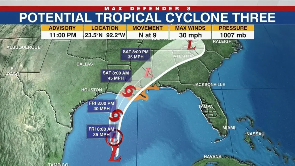
As the tropical system Invest 97L makes its way towards the eastern Gulf of Mexico, Florida is bracing for what could be a significant weather event. With forecasts suggesting that Invest 97L might intensify into Hurricane Debby by the end of the weekend, state officials and residents are on high alert. This blog will cover the current situation, the expected impacts, and the precautions being taken across the state.
Florida on High Alert: What to Expect
State Officials Urge Preparation for a potential hurricane. Debby Looms
State officials are urging Floridians to prepare for severe weather conditions as Invest 97L progresses. Although the system has not yet been officially named, forecasters are closely monitoring its development. If it reaches hurricane status, it would be named Hurricane Debby. Regardless of its official designation, the system is anticipated to bring heavy rains and strong winds, particularly to the Gulf Coast side of Florida.
Tropical Storm Watches and Warnings Expected
By Friday, tropical storm watches or warnings may be issued as the system approaches. These alerts will provide updated information on the storm’s trajectory and potential impacts. Floridians are advised to stay informed and follow official guidance as the situation evolves. The National Hurricane Center will provide timely updates and recommendations.

Where is Invest 97L?
Tracking Invest 97L
Invest 97L is currently located in the eastern Gulf of Mexico, moving towards Florida. The system is being closely monitored by meteorologists, who are assessing its development and potential impact. As of the latest updates, Invest 97L is expected to gain strength, potentially transforming into a tropical storm or hurricane within the next 48 hours.
Preparing for Increased Flood Threat
Flooding Concerns and Preparations
With heavy rains expected, flooding is a major concern. State officials are taking proactive measures to mitigate the risk, including offering free sandbags to residents in vulnerable areas. These sandbags can help protect properties from potential water damage and are being distributed at various locations across the state.
Free Sandbags are available for Residents
To assist with flood preparedness, Florida officials are providing free sandbags to residents. These can be picked up at designated distribution points. It is advisable for residents to act quickly and secure their sandbags before the storm’s impact intensifies.
Tropical Trouble Brewing: What’s Next?
Monitoring Tropical Storm Warnings
Tropical Storm Warnings are likely to be issued as Potential Tropical Cyclone 4, which is the designation given to Invest 97L, moves closer to Florida. These warnings will outline the anticipated effects of the storm, including heavy rainfall, strong winds, and potential flooding. Residents should stay tuned to local weather reports and follow any instructions from emergency services.
Urban Heat and Tropical Storm Impact
In addition to storm concerns, some cities in Florida are experiencing higher temperatures due to urban heat effects. The combination of intense heat and the approaching storm could exacerbate challenges for residents. Staying hydrated and cool will be important as the weather conditions evolve.
Expert Insights: Bryan Norcross on Tropical Storm Alerts
Bryan Norcross, a renowned meteorologist, has indicated that tropical storm watches or warnings are likely for Florida on Friday. His insights emphasize the need for residents to stay prepared and vigilant. Following expert recommendations and monitoring weather updates will be crucial as the storm approaches.
Table of Contents
Conclusion
As Florida remains on high alert for torrential rains and potential tropical storm impacts from Invest 97L, it is essential for residents to stay informed and prepared. With the possibility of the system becoming Hurricane Debby, the state is taking the necessary precautions to mitigate the effects of severe weather. By staying updated on official forecasts and preparing accordingly, Floridians can better navigate the challenges posed by this developing storm.


